
Urban planning
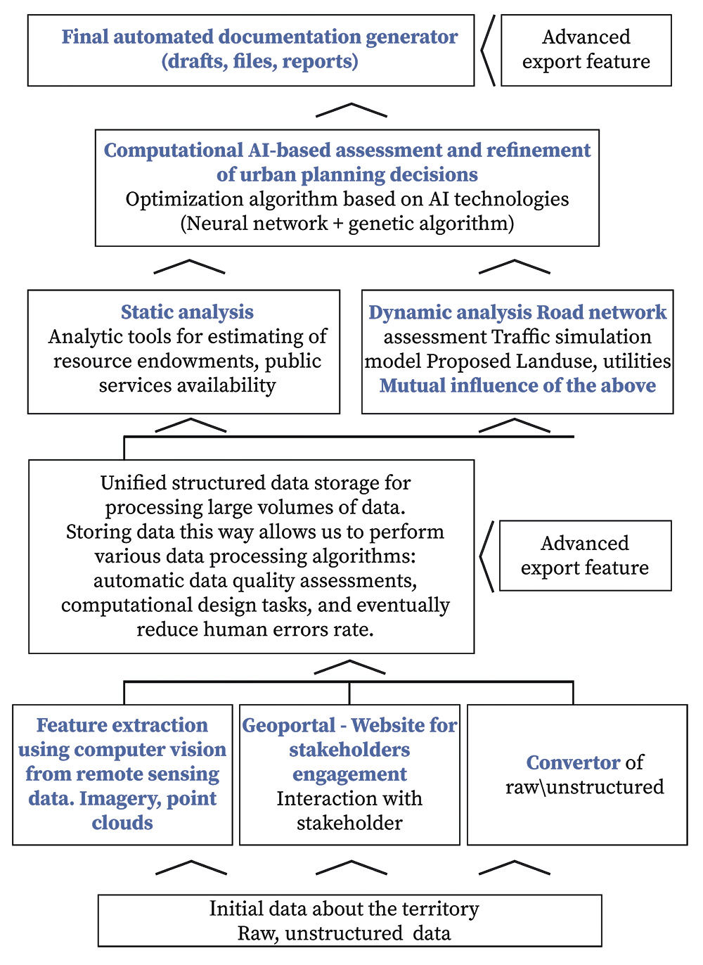
The platform includes a set of digital modules used at all stages of urban design: initial data gathering, stakeholder interaction, quality assurance, static, and simulation analysis of territory, city structure optimization, preparation of deliverables.
All these components make it possible to reduce the cost of design projects and the amount of human labor as well as improve the quality of outcome documents.
All these components make it possible to reduce the cost of design projects and the amount of human labor as well as improve the quality of outcome documents.
— 1
Conversion of raw data into a digital model in machine-readable format for further automation and data processing.
Conversion of raw data into a digital model in machine-readable format for further automation and data processing.
Smart Civilization "Data Lake" - repository for accounting of submitted materials from different sources: initial data gathered from stakeholders, final or intermediate results on each stage of work of the specialist, regional standards, results of surveys and many others; indicating the name of the source, date, status, information about approving documents, external organizations, territory, detailed description and files related to it.
Each data update or amendment documented and linked with source of amendment (responsible specialist, reason of amendment, date of amendment) for benchmarking and review to ensure completeness of deliverables.
After filling the "Data Lake" with all data, the process of conversion of data into a digital model in machine-readable form for further automation and data processing will proceed.
The digital model has a specific structure, a list of types of objects, type of spatial representation of objects, list of characteristics of objects, types of data for characteristics. The system is capable of performing a spatial analysis of the graphics of objects, displaying a list of problems, and eliminating errors such as self-intersection, duplication of graphics, etc.
The system automatically analyzes the uploaded materials for completeness and compliance with design standards, which ensures data quality and completeness.
All processed data will be fully available for specialists, client, stakeholders through Smart Civilization digital platform for export, review, further processing and the execution of works.
— 2
Static and simulation analysis, mutual influence of project decisions
Static and simulation analysis, mutual influence of project decisions
Having data in form of digital model, draft standards and policies for urban planning, the digital platform automatically indicate conflicts and contradictions of design decisions and analyze an impact of any amendments to the master plan.
Conflicts and contradictions of design decisions will be automatically tracked, for example, the inadmissibility of residential building in the protected zone, the prohibition of residential development in the zone of objects of archaeological monuments, the intersection of roads with treatment facilities, etc.
In case of insufficient completeness of data — GradInfo informs about it and indicates problems.
At the design stage, digital platform provides coordination of all design decisions, document versioning at every stage of drawing preparation, providing coordination within the team and all parties to reach agreement on the next steps.
Simulation analysis is an assessment of the transport structure with land use, utilities, and mutual influence of the above using a simulation model. The digital model identifies the optimal places for the placement of buildings/reconstruction of buildings and blocks in terms of the traffic capacity of the road network and vice versa. The simulation model highlights where traffic jams appear or travel access will be simplified, analyze the situation, and suggest approaches for solving them. As an example of accessibility analysis, the simulation visualizes the connectivity of blocks with each other, how difficult to reach it (from the point of view of the constructed route and the time of achievement), and how difficult to leave it.
— 3
Outcome generation
Outcome generation
The digital model includes functionality for automated generation of any type of drawings with appendices to the drawing, enlarged fragments of the drawing. The automatic legend feature supported as well, in accordance with standards. The scale and size of drawing sheets set automatically depending on the size of the territory.
— 4
Geoportal for stakeholder engagement
WEB-service "GeoPortal" is a special module for data transmission designed for publication of progress of the project execution on all stages of project, gathering feedback and updates from client and stakeholders.
Thus, the Smart Civilization Digital Platform ensures the high quality of data analysis and therefore the high quality and consistency of all the urban design solutions combined, which is the ultimate goal of our project.
Thus, the Smart Civilization Digital Platform ensures the high quality of data analysis and therefore the high quality and consistency of all the urban design solutions combined, which is the ultimate goal of our project.
© All Rights Reserved. Acme Design Co.
